Wildest Dublin

Lenny Antonelli walks the Dublin Mountains Way, one of Ireland's newest long-distance trails

Irish Times, 5 January, 2013

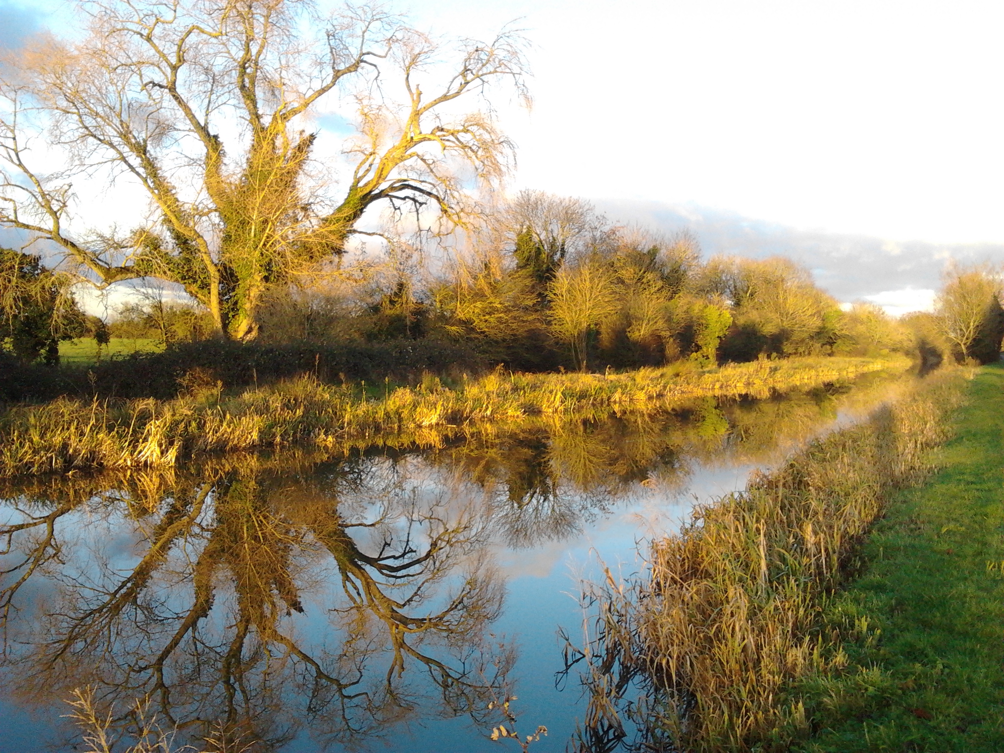
I went to Dublin seeking wild landscapes, not really expecting to find any. Living on the west coast I usually don’t travel far for this sort of thing. Going to Dublin to find mountains felt incongruous. Zig-zagging over the hills from Tallaght to Shankill, the Dublin Mountains Way is two years old. I started from the trailhead at Seán Walsh Park, Tallaght, aiming to make Glencullen by sunset. The trail skirted housing estates, then dropped me into comparative wilderness around the Bohernabreena reservoir, where the river Dodder was damned in the 1880s and wooded hills fall to the lakeshore.

This valley is also home to orchid-rich grassland and petrifying springs, where lime-rich water rises from the ground and deposits calcium carbonate in a white, crunchy coating.

The trail brought me into the hills, looking over to lime and rust-coloured slopes on Seahan and Corrig mountains. Walkers need to be cautious as this section is on narrow, windy roads.

I expected Celtic Tiger mansions up here and there were some. But it was mostly old stone cottages, hay sheds, farm yards and signs warning that dogs worrying sheep would be shot.

This valley – Gleann na Smól, glen of the thrushes – was one of the last places in which the Irish language survived near Dublin.

Heavy mist pressed down on the hills as I climbed. And though I couldn’t see them, I was surrounded by mountains.

The trail entered the Featherbed forest, but the name felt euphemistic as it crossed felled planation. I felt like a lone survivor in the aftermath of some brutal apocalypse, surveying a landscape of decaying tree stumps, black pools, churned peat and a few limbless trees. It reminded me of the writer Tim Robinson’s description of clear-felled forest in Connemara as “frozen at a moment of maximum horror”.

But soon I entered the forest at Cruagh, passing a mossy stone bearing an inscription to the naturalist HC Hart, who in 1886 bet a colleague that he could walk the 111km from Terenure to the summit of Lugnaquilla in Wicklow and back within 24 hours.

He won, returning to Terenure with 10 minutes to spare. The trail followed rows of mature spruce trees, heather, mosses, and flowering gorse.

I went up Tibradden Mountain and towards the summit of Two Rock, the way’s highest point. Writer and nationalist Stephen Gwynn described this area as “bare and lonely, as devoid of any suggestion of a great city’s nearness as even Connemara could show”. This is what I had come looking for, but I could only see a few metres of the trail rising into the clouds ahead of me.

Soon a gust of wind blew off the clouds to reveal Fairy Castle, Two Rock’s summit tomb, and the orange glow of the city below.

The trail brought me towards the huge transmitters at Three Rock. Writing in 1780, the artist Gabriel Beranger reckoned the mountain’s distinctive rock clusters were altars built to offer sacrifices. They are, in fact, natural granite formations.

But I was in trouble: the walk had taken longer than planned and the sky was blackening, so I donned a headlamp and high-vis jacket to descend Ticknock forest in the dark. The final stretch into Glencullen on country roads in the dark was the most treacherous bit of my walk – without a headlamp I’d have been in serious trouble.

The lesson? Walking from Tallaght to Glencullen is probably too much at this time of year – if you want to walk this route in winter, tackle it over multiple days, or just pick a sub-section.

Dublin Mountains Way

Map : Get trail maps from dublinmountains.ie (the DMW route can change). OSI Discovery Series Map 50 covers the area but shows an old DMW route. East West Mapping also publishes Dublin Mountains map.

Start : DMW trailhead in Seán Walsh Park off Kiltipper Road, a short walk from the Tallaght Luas stop. Or start anywhere along the route.

Finish : Johnny Foxes pub, Glencullen.

Time and distance : Tallaght to Glencullen is 20 miles with lots of ascending. Seven to 10 hours.

Route : Walking Tallaght-Glencullen in daylight during winter is a big challenge. Suitability: Bring food, water, rain gear and warm clothes, hiking boots, map, compass, high vis clothing and a torch/head lamp.

Take a walk on the Grand side

LENNY ANTONELLI walks a quiet section of the Grand Canal in Kildare

Irish Times, 15 December 2012

The Grand Canal Way is a rarity in Ireland: a long-distance walk that’s almost entirely off-road, stretching from Adamstown in west Dublin to Shannon Harbour, Co Offaly.

The section between Hazelhatch and Sallins is a perfect microcosm of it – a half day’s walk between two towns serviced by a railway whose own history is entangled in that of the canal.

I set out from Hazelhatch, where houseboats line the channel. This must be Dublin’s most chaotic and inspiriting row of homes: the barges are cream, red and highlighter blue, fat and slim, tall and squat. The towpath is decorated with bicycles, tables, old kayaks, wheelie bins, solar panels and wooden sculptures. Smoke rises from their chimneys, but nobody emerges from below deck, so I walk on.

Work began on the Grand Canal in 1756 in Clondalkin. But progress was slow, and it took more than two decades before the 20km channel to Sallins was open. Further west, the immense Bog of Allen almost sunk the project when clay walls built to support it failed. The Grand Canal finally reached the Shannon in 1803, but the age of fast rail travel was looming.

For those who normally walk the mountains or coast, the canal is an entirely different creature. While hillwalking is adventurous, canal-walking is ponderous – you needn’t worry about navigation or the terrain here, the towpath just carries you endlessly forwards. But our canals play a crucial ecological role, linking up rivers and lakes that would otherwise be isolated. And their landscape makes you pay attention for its subtler rewards, like a moorhen hiding in the sedges, or bubbles breaking on the water’s surface, perhaps released by a tench eating grubs on the floor of the canal.

Like a forgotten thoroughfare it sneaks behind fields and country estates. It’s hidden from Kildare’s modern commuter towns, and has an architecture all of its own. I passed steep stone bridges, derelict lock-keeper’s cottages, and an old canal-side church and school at Ardclough. I walked by the old Lyons demesne, with its immense Georgian manor, and Oughterard, where Arthur Guinness is buried and Daniel O’Connell killed John D’Esterre in a pistol duel in 1815. Bring a map though: often these features are behind high walls or rows of ivy-wrapped trees.

About half way to Sallins, the light started to disintegrate. Colour drained from the landscape, leaving only the black trees and the shadows they cast on the inky water. Walking in the half-light was thrilling, though, and dead silent except when my presence sent terrified birds screaming from the trees.

Soon I passed under the railway bridge just before Sallins. The Grand Canal Company fought the building of the railways, and this bridge proved pivotal: once the Great Southern and Western Railway Company won the right to bridge the canal in the 1840s, the rail network could stretch out to Cork, Limerick and Galway. Just two decades later, the mass transport of people and goods on the canal was finished.

WALK THE GRAND CANAL WAY

Map : OSI, Discovery Series, Sheets 49 and 50. Downloadable maps of the Grand Canal Way at  (see also for train times).

Start : Hazlehatch Bridge, 600m from Hazelhatch and Celbridge rail station.

Finish : Trail ends at Sallins.

Time and distance : 12.6km. Takes four hours if you want to explore slowly.

Suitability : Easy. Bring food, water and warm, waterproof clothes and footwear.

Rail services: On the Dublin-Kildare line, with trains leaving Heuston station frequently.

The waters and the wild

LENNY ANTONELLI encounters a trout river and deceiving mushrooms

Irish Times, 24 November 2012

The terrain between the northern end of Lough Corrib and the mountains of Connemara is tough to categorise. It’s a place where flat lakeland meets quartzite peaks, yet it doesn’t belong to either. The region’s folding plateaus are softer and greener than the neighbouring mountains, yet more complex and cryptic, and less walked. The stretch of the Western Way between Curraun Beg and Maam Cross offers an easy introduction to this zone of transition. Right at the end of a cul de sac winding 13km from Oughterard, the trailhead is a remote spot with few houses and a patchwork of field and forest that includes modern plantation and scraps of old woodland. The electricity network didn’t stretch here until 1975. The car park looks across a narrow neck of the lake towards the sessile oak woodland on the Hill of Doon.

The trail goes west along the boreen under Curraun Hill, past the ruins of a 19th century national school, and into a mossy conifer plantation. Hop over the stile at the end of the forest and on to the open bog.

Heading towards Lackavrea mountain, the trail crosses a footbridge and enters a vast conifer plantation near a townland known as Doirín na gCos Fuar – the small wood of the cold feet. According to cartographer Tim Robinson, local folklore says a herdsman was killed by a bull here, and all that was found of him was his feet. But Robinson says the term “cosa fuara” also referred to poor people, or newcomers to an area, so the name could have a more prosaic explanation.

The trail follows the Falamer river, where brown trout spawn in autumn and winter. The females excavate nests in the gravel bed of the river, then lays eggs that are immediately fertilised by the male. The female covers the nest, known as a redd, and the fish that hatch in spring will spend a year or so here before migrating downstream to Lough Corrib.

After the trail leaves the river, the rest of the walk to the Maam valley is a fairly dull slog through the plantation, so you could turn back now. But I decided to persevere, and the abundance of mushrooms growing beside the boardwalk was enough to hold my interest, their names as curious as their shapes and textures: the deceiver, the sulphur tuft, the sickener.

Lackavrea mountain appears through gaps in the forest. This is a rough and complex mountain, as indicated by its Irish name Leic Aimhreidh, the rugged rock-slab. The trail eventually leaves the forest over a footbridge, crosses the bog and emerges onto the road under the Maamturk mountains.

Oscar Wilde’s father William wrote about a similar journey, from the lakeland into the mountains, in his book Lough Corrib: Its shores and islands, but by boat instead of on foot.

“Steering through the narrow intricate passage under the wooded promontory of Doon, we literally leave Lough Corrib and the scenery of Mayo behind us, and pass into another region, grander, wilder and more romantic,” he wrote.

WALK LACKAVREA FOREST, CO GALWAY

Map : Ordnance Survey Ireland, Discovery Series, Sheet 45

Start: Car park at Hill of Doon viewpoint

Finish : The trail emerges onto the R336 between Maam Cross and Maam village.

Time and distance: The full linear walk is about 9km and takes about three hours.

Suitability: Easy to moderate. Map, waterproof boots, warm clothes, rain gear, food and water essential.

Dizzying Donegal

LENNY ANTONELLI explores the seascapes of Gleann Cholm Cille

Irish Times, 27 October 2012

DRIVING IN FROM the bog above, Gleann Cholm Cille appears like a Greenlandic outpost, a scatter of low buildings enclosed by sea and mountain. A web of bog tracks takes you into the hills north of the village – a branch from one leads to an early 19th-century lookout tower, on the 220m cliffs at Glen Head.

Local teacher Thomas McGinley found this height too great to comprehend the sea below. “Both vision and hearing fail . . . at this awful altitude,” he wrote.  McGinley walked this coast in the 19th century, documenting its wildlife and history. The Derry Journal published his notes weekly under the pen-name Kinnfaela, and later collected them in a book The Cliff Scenery of South Western Donegal.

I abandon the trail at the tower and follow the coast. Soon the cliffs indent sharply and the ground drops steeply to a small valley – move inland to cross the valley safely and rejoin the cliffs on the other side.

Up ahead the coast cuts out to sea at a right angle – this is the Sturrall, a vertical headland where locals once picked edible rock samphire, McGinley wrote. Some even descended the cliff to gather seaweed on the shore far below.

His book tells the story of a rector’s son who planned to swipe eggs from an eagle’s nest on the Sturrall. Locals warned against it, but this hardened the lad’s ambition, and he raved about the idea in his sleep. One night he sleepwalked up to the cliffs and strode out the Sturrall through wind and rain. The next morning he told his mother he had dreamt of robbing the nest, and she promptly handed him the eggs he’d brought back in the night.

Following the cliffs, the terrain shifts from dry heather to muddy bog to a forest of dead ferns. Two choughs let out laser-like calls above me – these red-billed crows live along our western coasts, but their numbers are declining.

Soon a track leads down to the shore at Port, a ruined settlement that was home to a few shepherds during the 19th century. Nearby in 1870 a storm sunk the Sydney, a cargo ship taking timber from Quebec to Scotland. Four of the 19 dead are buried at Port.

I climb up Port Hill along the cliffs for a view of Tormore, Ireland’s highest sea stack. Local folklorist Seán O’Heochaidh told a story of the stack: Jack Mór climbed it to hunt seabirds during the famine. He met another man on the same mission, and both filled their bags with birds. But Jack Mór weakened on his way down and couldn’t carry on. The other man went for help, but a great storm blew in. Jack Mór was stranded for a fortnight. When his rescuers arrived, there was nothing left of Jack but his bones. It was said these could still be seen on the side of Tormore 70 years later.

Daylight was against me and it was time to head back down to Port, where the bog track offers a different return route to Gleann Cholm Cille. Since setting out, the valleys had grown progressively more remote: first Gleann Cholm Cille itself, then the backwater of Port, and now ahead of me was Glenlough, with ruined cottages that no road reaches.

The American painter, Rockwell Kent, stayed at Glenlough in 1926 while painting this coast. The Welsh poet, Dylan Thomas, spent a summer there too, trying to wean himself off alcohol by walking and writing. But the black nights and isolation got to him, and in letters to a friend he recalled encounters with Count Antigarlic, “a strange Hungarian gentleman . . . coming down the hill in a cloak lined with spiders”. The local poitín may have gone to his head.

Map: Ordnance Survey Ireland, Discovery Series, Sheet 10.

Start finish: We parked in the townland of Beefan, just north of the village, joining the bog track around grid reference G 524 858.

Route: My walk followed sections of various official trails, starting on the Tower Loop. The bog track from Port back to Glencolmcille is part of the long distance Slí Cholmcille, and also joins the local Drum Loop. Seeirishtrails.iefor details.

There is a map board of local loops at the walking centre in the village. Do not attempt a shortcut back to the start point by going off trail across Beefan and Garveross Mountain – its south face is extremely steep.

Suitability: Inexperienced walkers should keep to the marked trails and avoid open mountain and cliff. Utmost care and attention required. Stay inside the intermittent fence. Map, warm clothes, good boots, rain gear, packed lunch, food and water needed. Compass and navigation skills required if heading off trail.

Time: Six to seven hours for my route, or four for both local loops.

Distance: My route was about 19km. Combing both local loops is 13km.

Services: Shop, food and accommodation in Glencolmcille.